A First Walk Through a Regional Plant Community
Read a regional plant community on a short walk by recording which plants grow together, how vegetation is layered and where one grouping gives way to another.
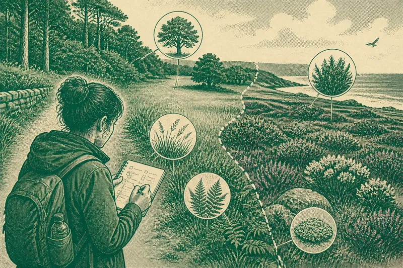
A regional plant community becomes easier to recognise when you record which plants grow together and how their forms fit the place. On a short walk, compare patches by their dominant growth, layers and visible relationships, rather than treating every change in ground or slope as the main clue.
Think of a plant community like a group of objects arranged for different uses: the pattern matters more than any single item. A woodland edge, coastal path, heath or grassland can be read through the plants that share it, even before you know every name.
Choose a vegetation route
Pick a marked path with at least two visibly different plant groupings, such as open grass beside scrub or woodland beside heath. Stay on the path and check local access notices. Avoid trampling fragile plants for a closer look.
Bring a notebook or use your phone’s notes. A camera can help you recall overall growth forms and leaf details, but do not pick plants. If you use a field guide, choose one for the region you are walking in; a guide from elsewhere may suggest plants that do not fit the local setting.
At each pause, use the same sequence: note the dominant growth, scan for lower layers, then record which plants occur together. Add the date and season. This keeps comparisons focused on vegetation rather than on a changing list of isolated observations.
Read plant groupings
Start with broad forms you can see clearly: trees, shrubs, grasses, flowering herbs, ferns, mosses or lichens. Note which forms dominate and which appear only beneath or between them. Some places have few visible layers, and that is still useful information.
Then record relationships. Do several plant forms grow in a continuous patch, occur in scattered clumps, or appear only at the edge of another grouping? Describe what is visible without assuming that one plant causes another to grow there.
Distinguish a local cluster from the broader community. Plants beside a path may reflect disturbance, so compare them with another patch visible from the trail before describing them as typical of the area.
Describe uncertain plants
When names are unclear, describe a plant’s form rather than guessing. Useful details include whether it is woody or soft-stemmed, tall or low, broad-leaved or narrow-leaved, flowering or not, and whether it grows singly or in a mat.
Say you are walking beside a woodland trail and cannot distinguish several low plants. You note that one forms a dense mat, another grows in small clumps, and a third appears beside fallen logs. Later, you compare those descriptions and photographs with a regional field guide. The resulting record separates the plants by visible traits, even if you still cannot identify every one.
An identification app can suggest possibilities, but check its suggestions against visible features and a regional guide. If the plant lacks a clear flower or leaf detail, keep the description and leave the name uncertain.
Compare plant boundaries
Notice where one grouping becomes less common and another more visible. The boundary may be gradual, such as low shrubs giving way to taller growth, or sharp, such as a scrub edge beside open grass. Record the plants on both sides before suggesting why the pattern changes.
Look for community-specific clues: a change in dominant growth form, a new layer beneath taller plants, or a shift from scattered individuals to continuous cover. These observations help you describe vegetation directly, without assigning a cause you cannot confirm.
If a patch is dense, check what can actually be seen beneath it. Record “lower layer not visible” rather than “no ground plants” when taller growth blocks the view.
Keep comparisons reliable
Season affects which plants are easy to recognise. Flowering, fruiting, dormant growth and cutting can change what stands out, while taller plants may conceal shorter ones. Note the season and any conditions that limit visibility.
Use this checklist at each stop. For every observation, follow the decision that fits what you can see:
- Check the dominant growth form; if trees or shrubs define the patch, record them first, then note any visible lower layers, or describe the patch as open if no woody growth is present.
- Check whether grasses or flowering herbs form continuous cover or scattered clumps; if one pattern is clear, record it, or note that the cover is mixed when neither dominates.
- Check for mosses, ferns or lichens in visible places; if present, record where they occur, or write “not visible” if cover or distance prevents a clear view.
- Check whether the same plant forms recur across the patch; if they do, describe the grouping as repeated, or note the change in form where the pattern breaks.
- Check the boundary with the next patch; if one grouping gradually gives way, record the order of change, or name the visible edge if the transition is abrupt.
- Check whether a plant can be identified from visible features; if a name is clear, record it, or keep a plain description and a photograph for later comparison.
- Check whether the season hides flowers, fruit or leaves; if key features are absent, mark the identification as uncertain, or use another visible growth form to compare the patches.
Questions along the path?
How many stops should I make?
Pause wherever the plant grouping visibly changes, rather than aiming for a fixed number. A few clear comparisons are more useful than hurried notes from many similar patches.
Should I identify every plant?
No. Record names you know and describe uncertain plants by their form and grouping. A clear account of where a plant grows is more useful than a guessed label.
Can an identification app name plants reliably?
An app can offer possibilities, but compare them with visible features and a regional guide. If the plant is out of flower or partly hidden, keep the identification open.
What if the vegetation looks uniform?
Compare small patches by dominant growth, plant layering and the way individuals are distributed. If those features also appear similar, record the lack of visible change rather than inventing a boundary.
Keep the record useful
Organise notes by patch, not just by plant name. Keep the location, dominant forms, visible layers, uncertain descriptions and relationship to neighbouring vegetation together. This makes it easier to see how a regional plant community is arranged.
For example, your notes might describe low shrubs and grasses recurring on an exposed path edge, then taller growth with a visible lower layer near woodland. Keep that as an observation, not a claim about what caused the difference.
Before leaving, write one specific comparison to revisit, such as whether the same plant groupings are visible when flowering makes lower herbs easier to distinguish. That gives your next walk a clear purpose without turning an uncertain name into a conclusion.