Why Mountain Ranges Often Guide the Shape of a Region
Mountain ranges guide regional shape by shaping slopes, passes and valley corridors. Learn how to read a ridge and its surrounding terrain on a map.
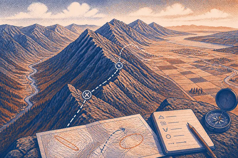
Mountain ranges guide regional shape by steering slopes into different valleys and concentrating crossings at lower gaps. Open a topographic map and the pattern becomes clearer: broad uplands, steep flanks, enclosed basins and low passes fit together like pieces of a jigsaw, though the boundaries are rarely neat.
Read the range as a landform first, not simply as a line separating rivers. Its height and shape affect which slopes face one another, where valleys open, and how easily people can cross between neighbouring areas. Water drainage can add useful context, but it is only one part of the landscape story.
Read the landform
Start with the broad shape of the high ground. A mountain range may have a sharp crest, a rounded upland, or several parallel ridges with valleys between them. On a topographic map, closely spaced contour lines indicate a steep slope; widely spaced lines indicate gentler ground. Follow the pattern across the whole range rather than treating each peak as a separate feature.
Use shaded relief alongside contours if your map offers both. Shaded relief makes the overall form easier to picture, while contours help you judge where slopes steepen or ease. Check the map legend and contour interval: a small change in elevation may be invisible on a map designed to show a broad region.
Next, look at the land on either side. A range may rise abruptly from a plain on one flank and descend through foothills on the other. That contrast can create a clear regional edge. Elsewhere, rolling uplands blend gradually into neighbouring terrain, so the boundary is less distinct.
Trace slopes and basins
Valleys often begin in hollows or between ridges, then widen as they descend. A series of parallel valleys can make a range feel like a set of corridors rather than a single barrier. Broad basins and plains provide a different kind of structure: they open space between uplands and can gather settlements, roads or farmland.
Look for changes in valley direction and width. A narrow valley opening into a broad plain marks a shift from confined terrain to a more open landscape. A valley that runs along a range may offer a natural route through otherwise steep country. These patterns can reflect rock type and erosion as well as elevation, so avoid assigning every bend to the mountain crest alone.
Imagine a map showing a long ridge, a bowl-shaped basin on its eastern side and a narrow valley running parallel to the western slope. Mark the basin and valley, then compare their openings with the nearest lowland. You would expect to see two different regional connections: the basin opens towards one neighbouring area, while the valley provides a lengthwise corridor along the range.
Find useful crossings
A saddle is a low point between higher ground. On a contour map, identify it by following the contours around two nearby rises: the lines form closed loops around each high point, while the ground between them drops before rising again. In profile, it resembles the shallow dip between two humps. Do not rely on a single bent contour; compare the surrounding contours and, if available, the map’s shaded relief.
A pass is a route through a range that uses a saddle or another relatively low crossing. A low point is not automatically an easy route: steep approaches, cliffs, unstable ground or access restrictions may matter. Check route information and local conditions before treating a mapped pass as usable.
Compare possible crossings by looking at the terrain on both sides, not just the lowest-looking point. A slightly higher saddle with gentler approaches may connect more directly to a valley or road. The map can suggest a route; it cannot confirm current access or ground conditions.
What do map features reveal?
How can I tell a ridge from a valley?
On a contour map, closed loops usually mark a hill or summit, while contour lines that form repeated V shapes point upstream in a valley. Check the surrounding pattern: ridges separate lower ground, and valleys collect it.
What makes a mountain pass different from a summit?
A summit is a high point; a pass is a lower crossing between higher ground. Look for the dip between neighbouring rises and compare the slopes leading to it before judging whether it offers a practical route.
Can a range shape settlement patterns?
Steep slopes and narrow valleys can limit where buildings and roads fit, while broad basins and gentler foothills provide more room. Local access, land use and history also influence settlement, so the terrain is one part of the explanation.
Why do some ranges have parallel valleys?
Long ridges can channel valleys along their sides, and differences in rock resistance can help shape the pattern. Read the whole sequence of ridges and valleys rather than assuming that every range has one central crest.
Map the regional pattern
For a focused map reading, make a simple overlay and record what each feature suggests. Each mark should lead to a decision, not just decorate the map:
- Check whether the high ground forms one continuous ridge; if it does, trace its length, but if it breaks into parallel ridges, map each separately.
- Check contour spacing along both flanks; if lines bunch together, mark a steep zone, but if they spread apart, note a gentler approach or foothill.
- Check for paired high points with lower ground between them; if contours show a clear dip, mark a possible saddle, but if the shape remains unclear, consult shaded relief or a larger-scale map.
- Check whether valleys run towards, away from or along the range; if several share a direction, mark a corridor, but if they diverge, treat the area as a more complex transition.
- Check where a basin or plain meets the range; if the opening is broad, mark a regional connection, but if steep slopes close it off, look for another route into the lowland.
- Check mapped roads and paths at crossings; if route information confirms access, consider the crossing, but if access or conditions are uncertain, do not assume the route is usable.
Say you are reading an invented map with a ridge, two possible saddles and a broad plain to the north. The first saddle has a clear dip but steep contour spacing on its southern approach; the second is slightly higher, with gentler contours and a path shown leading to the plain. Mark the first as a low landform crossing, but choose the second as the more plausible route to investigate because its approach and connection appear easier. The map still cannot settle access or current conditions.
Check the landscape
From a safe public viewpoint, compare the skyline with the map. Note whether the crest is continuous, split into parallel ridges or interrupted by low gaps. Then look for valley mouths and broad lowlands. A viewpoint helps you recognise the shape, but it will not show every hollow or establish where water flows.
On a walk, stay on permitted paths and notice how the ground changes from slope to foothill or basin. Avoid unstable banks, steep ground and fast watercourses. If a map is being used for a planning, land-management or access decision, check authoritative local mapping and consult a qualified professional where appropriate.
Mountain ranges guide regional shape through their slopes, valleys, basins and crossings, not through a crest line alone. On your next map, trace one ridge, compare the land on either side, and mark the nearest broad lowland and plausible pass. That combination gives you a more useful picture of how the range organises the surrounding region.